The Standing Mast Route through The Netherlands is known to many a sailor. We have been through the northern part once before, but that was mostly for transport. So for the summer of 2023 we thought that we would spend more time and enjoy the canals.
We found some blogs and posts about the route, but not as detailed as we could wish. Our dedicated navigator, also being my wife, spent many a winter evening looking for information on the internet. There are a whole lot of bridges and many locks that must be passed, and it is necessary to know details about opening hours, dimensions, contact info and status. In the year of 2023 there is of course an app that will solve that, and for the most of it the Waterkaarten app will do. But there are also other concerns, like marina details, anchorages, other moorings, depths etc. The navigator put a lot of this location information into Google Earth, so we could have a nice combined overview. Also a new and updated chart for the plotter was a priority for Dutch waters .
The plotter is our main navigation aid. We like to have a backup or two, but do not want to spend a fortune buyng commercial marine charts for many units. So we have Open CPN on Android and PC as a backup. The charts are not quite up to date for the whole trip, but will do for som basic navigation. Luckily, for the most critical areas like the coast of The Netherlands, the Dutch government produce frequently updated downloadable charts that can be read by Open CPN.
For 2023 we found it here: https://vaarweginformatie.nl/frp/main/#/home. Go to Elektronische vaarkaarten and find the files.
The sailing to The Netherlands can be done in much shorter time than we spent, but we always like to take our time and enjoy the journey and the coasts. The transition from Norway to Germany will be known stuff to most experienced sailors. Maybe the Kiel canal also. I believe most people do not spend much time in there. But when the weather is good, there are possibilities to enjoy some pleasant and sheltered days . We were lucky, May and especially June of 2023 was a warm period with excellent weather. Places like Borgstedt (anchor), Rendsburg, Gieselau and the lock city of Brunsbuttel are possible stops.
In favourable conditions, sail can be set to reduce fuel usage in the Kiel canal. The engine is supposed to be idling in standby. I like to try to use the foresail, but I found that even with a theoretically good wind, the tall and large trees on the banks block the wind too much, and also induce a lot of turbulent eddies.
Sail rolled in due to turbulent conditions, as can be seen on the water.
The plan was to go from Brunsbuttel via the German islands Wangerooge and Norderney to Delfzijl and start the canal journey through Groningen. Out of Norderney most probably a routing over the shallow Waddensee. I do however not like the Waddensee too much. The depths are not that pleasant even at high water, the bottom changes frequently, the maps must be accurate and up to date and I am not experienced in navigating there.
Planned route from Brunsbuttel.
There was a bit of calculating to do regarding arrival at Wangerooge, as the entrance is too shallow at lower tides. The times seemed to match our planning cruising speed, and we were also able to take advantage of the falling tide out of Brunsbuttel the whole way out to the North Sea. And even better, in this period easterly winds and warm weather prevailed, so we did not have to fight the usual westerlies.
In Wangerooge, luckily, we talked to a Dutch family. They told us that there was a bridge over the canal between Delfzijl and Lauwersmeer that had technical problems and only opened once a week! So we had to replan to start the canal tour from Lauwersoog, skipping Groningen. Maybe we should have had a way and routine of finding that out ourselves.
The tides in these areas are significant, and for normal sailboats the difference between having the current with vs against is great. We were able to arrive at the entrance towards the Lauwersoog lock area before the turn of the tide, at fairly high water. Good in more than one way. We had a bit of a scary experience. Our Navionics plotter chart had the latest update, and the depth margins on it were good, so we trusted it would be no problem as long as we stayed deep, also having more than 2 meters in tidal margin. Not so. The navigator was at the helm, and noticed the depth indications rapidly and dangerously decreasing. Very confusing and not according to chart. We decided to turn straight back into our track and take the sails down.
We are quite used to not always sailing inside the marked waterways. In our home waters, the markings of waterways are usually made with margins for much deeper vessels than ours, and we use our common sense, based on fairly accurate charts, to shortcut. So we had not based our navigation on the markers. The navigator suggested we carefully head for the nearest waterway marker, which was a good idea. Inside the waterway we found safe depths.
What had happened?
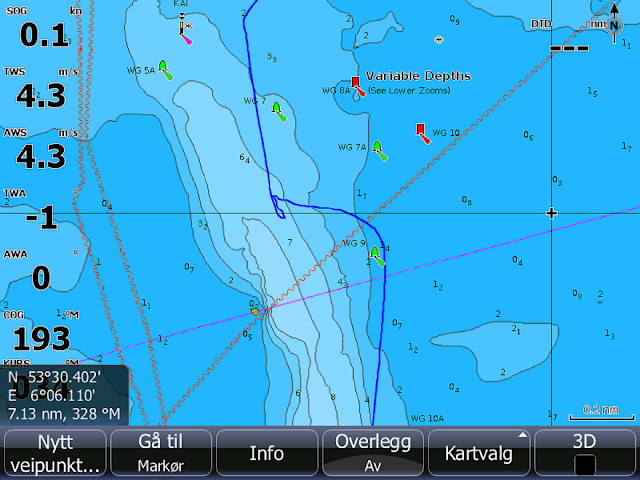
Above is the track and it shows the position where we turned around. Chart depth 6 meters plus, and 2 meters tide on top of that. Our indications were rapidly approaching 2 meters. The newly updated Navionics chart that we had just bought for a stiff price had led us astray. When checking the Dutch
charts that we had in the standby database, this is what we could see:
The track is here yellow. The chart shows a completely different sea bottom. (The blue plotted planning and distance route is based on another chart). If we had not entered this area with tide margins, we could have gotten in serious trouble at that sandbank. Retrospectively we should of course have checked other chart sources, but with a new chart, good depths and a good tide margin we had seen no problems.
Approaching the Robbengat lock by Lauwersmeer pretty close to closing time, we contacted the lock operator by VHF. Officially open till 19:00, but taking in the last boats at 18:45 he told us. If we could be by the lock at 18:45, we could get in. Sailing in a brisk breeze , we turned upwind and lowered sails just in time to be the last and single boat in the lock that evening. There is a marina on the seaside of the lock, but we were now keen on leaving tidal worries. We dropped anchor outside the Jachthaven Nordergat inside, in the Lauwersmeer. The canal tour was beginning.
The next day was June 16. We had spent a whole month since leaving harbour in Norway. June 2023 was a very sunny and warm month in most of Northern Europe.
The navigator had spent much time locating, detailing and listing Marrekrites in Friesland. Ourselves, we did not know of this word before planning the trip. But we had heard there were some kind of free moorings somewhere in The Netherlands. In fact, it is only the region of Friesland that has these. Marrekrites are jetties for longside mooring, they are common along the Friesland canals and also in the nature reserves. They are mostly fairly small, with space for 2-4 boats. But there are also some bigger ones. The Marrekrites are located in the countryside, most often near fields and agricultural areas ( I believe most of The Netherlands is agricultural). You can stay a maximum of 3 days. At daytime there will be a lot of traffic passing, but at night it is quiet, because the locks and bridges are closed. There are also some buoys in Friesland that are used according to the Marrekrite kriteria.
Above a couple of Marrekrite examples.
In warm and nice weather we sailed a fairly short distance to our first Marrekrite, a quite big one that had looked promising during planning. It is at a little island called Senneroog, with a little lagoon. Considering the good weather we feared it was all occupied, but we found a nice spot.
Already the first day in the canals it was obvious that we could be glad that our draft is not above 1,5m, actually only 1,2m. In my experience it seems like 1,5m is kind of a standard minimum depth at the Marrekrites, and very often it is not much more. Also, in the canals the waterway markings are made for small boats, so do not shortcut or stray outside without good depth information!
The water in the canals is really murky. But with temperatures approaching 30 centigrade, we just had to go for a swim now and then. Swimming in the canals never made us ill, but I believe it is a good idea to keep the head above water and not do it with any open cut or skin injury.
After a couple of quiet days and nights we wanted to proceed towards Dokkum. The plan in Friesland was to use the Marrekrites ahead of stays in cities, to save a bit on harbour fees. Now, Dokkum has a very boater friendly price regime. I think they are smart. The harbour is always full of boats, and that should also be to the benefit of restaurants and businesses in town.
Again, low draft is an advantage. You can not expect to choose between a lot of mooring spots. And at one location, we read 10 cm less than our draft. Luckily very soft mud. Another speciality of Dokkum is that one can leave the garbage bag on the side of the boat in the afternoon/evening and it will be picked up from there in the evening or next morning. Not so easy to know, but the fee collector told us.
Part of Dokkum harbour. A shallow corner.
Out of Dokkum was the first bridge passing where we had to pay for the opening. €5 is a bit more than elsewhere, but it is for 2 bridges served by one person bicycling between. Well paid excercise. All in all there were not so many bridges that required payment on our route. Maybe because there is a lot of traffic, and having each boat stop to pay cash will slow everything considerably down. We had made an effort to get a lot of coins, but around €15 would have been enough for us. That said, some marinas are inside bridges and thus more coins may be required.
Leeuwarden has this special guest harbour that is part of a park in the middle of town. The canal banks are used as moorings. Very nice, and not far from a bustling centre.
Differences in climate and population make wonderful summer scenarios like this in Leeuwarden centre much more common in Central Europe than in Norway. Also, being pleasant and peaceful, a case for afterthought this year.
A visit from our daughter was planned some time during this trip. And to fit her working schedule, it was decided that we would go to Amsterdam a bit earlier than the original plan. Thus Harlingen became the next stop, then next day into the Ijsselmeer via the lock and further to the Enkhuizen anchorage. There is some information stating that €10 can be charged for anchoring there, but nobody claimed anything. Enkhuizen is a cosy town that we have visited before, and especially the inner harbour area is full of life in a nice summer evening.
There was a gathering of beautiful Dutch sailbarges in the inner Enkhuizen harbour.
To sail from Enkhuizen to Amsterdam, we went through a lock slightly down to Markermeer, which is technically a different lake. It was originally closed off as part of a plan to fill it in and regain a large area of land, but the plan was later abandoned. Both Ijsselmeer and Markermeer are freshwater lakes. They are shallow, but can generally be sailed upon by pleasure craft almost anywhere. Markermeer is the shallowest, with depths around 3-4 meters. This makes a fine bottom for long plants that grow up towards, and also reaching the surface. At the time they were not so abundant, end even though there were some bundles floating around, there were no real problems. The shallow water is easily warmed by the sun in summer, and we could engage in one of our favourite water activities, hanging after the boat in a line while sailing slowly.
The dike contours and different waters of Ijsselmeer and Markermeer can be clearly seen on Google Earth.
There is a lot of information online about how to navigate locks and bridges, so most of that I will omit. Just know if you are locked down or up, keep mooring lines easy to adjust, green light only is "enter".
Beware that even if bridges are fully open, opposite traffic may get the green light first.
There are a few marinas in the Amsterdam area. As we are sailing a catamaran, Amsterdam Marina is by far the best for us. Both Amsterdam Marina and Sixhaven have frequent free ferry connections to the Central Station.
When planning this trip, som information about a newly established "vignetplicht" surfaced. The Amsterdam authorities has allegedly decided that pleasure craft going for the Standing Mast Route via Amsterdam waters has to pay some sort of fee. Calling Amsterdam Marina ahead of time, they were of the opinion that enforcement was not established for this. And nobody approached us with any check or claim.
The plan was to continue via the western part of the Standing Mast Route southwards via Haarlem. But when checking on the locks and bridges southbound, it was not so tempting, as we now had a guest for some days. The railway bridge south of Haarlem was closed for opening, and the motorway bridge and the first lock had only a few openings daily. We did not want to waist these days waiting for openings and only getting to Haarlem, so we actually cancelled the southern part, having in mind a plan to also spend time in southern Denmark in july. Thus some days were spent in Volendam by Markermeer.
So lesson learned from Delfzijl and Amsterdam is to check the route thoroughly , sailors told us that bridges not seldom go unserviceable. We only learned about the Haarlem railway bridge when calling a marina in that area.
We then headed for the southeastern route northbound, to be joined at Lemmer. Someone told us that the plant growth in the area towards Enkhuizen had increased a lot, and that it would be better to go via the lock at Lelystad. At times some areas in Markermeer become virtually unsailable due to the amount of plants on the surface. We had no idea about that beforehand.
The route from Lemmer to Leeuwarden passes through two towns, Sneek and Grou, Sneek being largest. Nice places to stop. The forecast for July 5th was for hurricane force wind gusts up to 32-50 m/s over central parts of The Netherlands, summer storm Poly. We used all our lines to tie up in the Grou marina. Strong winds came, but we never saw over 22 m/s.
Forecast from dmi.dk regarding Poly.
There are lots of opening bridges to pass on such a trip, but generally there was not much waiting time for us. The boaters in The Netherlands are really getting attention. The Amsterdam area may be different. And for railway bridges 30 minutes could happen.
Passing one of the bridges in Burdaard.
Inbound and through Leeuwarden from the south, there were 9 bridges in a fairly short distance, obviously that will take some time.
Some bridge openings are fairly narrow for catamarans, 8 meters is not uncommon. Usually no problem for our 6,5m beam unless there is much sidewind and slow traffic ahead. But we went into a narrow canal at Warten. It was unplanned, since we had not understood that the Fonejachtbrug over the canal towards Leeuwarden does not open any more, and thus had to turn back. The Warten bridge is only 7.4 meters wide, and I really felt we filled the whole gap. A couple of fenders sprang into the air.
The canals have murky water, but it is not saltwater. Thus you have a zillion liters of washing water available as the boat gets dirty. And you do not have to go into a harbour or marina to wash off the dust and dirt that will inevitably accumulate on deck.
A rough outline of the route.
Blessed with good weather this trip was a pleasant experience. Even though the Norwegian currency was really weak in the summer of 2023, costs were not high compared to Scandinavian waters. Mooring fees averaged slightly lower, and the Marrekrites also helped to keep costs down. Food and restaurants were also about the same as home, with the usual exception of alcoholic beverages.


